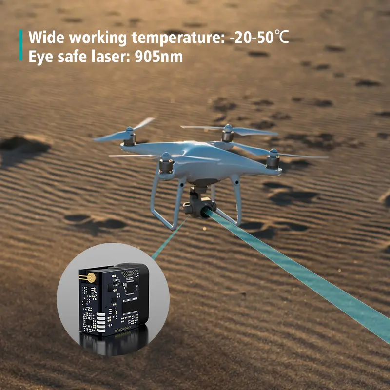
Accurate height profiling and fixed-point medición de la distancia are essential in UAV inspection, structural monitoring, mapping, and industrial automation. As drones, robots, and smart monitoring systems continue to advance, the ability to measure long-range distances with precision has become a core requirement. A high-performance distance detector sensor, based on phase-measurement iToF (indirecto) Tiempo de vuelo) technology, provides the accuracy and stability needed for modern engineering environments.
Distance detector sensors are widely used to measure height, detect structural displacement, evaluate material levels, and analyze changes in terrain or surface profiles. Their non-contact nature makes them suitable for UAVs, gimbal payloads, industrial machinery, and fixed monitoring stations, especially in outdoor or low-reflectivity environments.
1. The Role of Distance Detector Sensors in Height and Surface Measurement
A distance detector sensor determines the distance between the device and a target surface using laser phase-difference analysis. This allows it to perform tasks such as:
- Measuring building or infrastructure height
- Monitoring snow depth, soil accumulation, or material pile levels
- Detecting water-surface elevation or river-level changes
- Identifying structural displacement across time
- Supporting precise altitude control for aerial inspections
- Guiding engineering decisions in topografía y construcción
Because these measurements are taken without physical contact, the sensor can operate in challenging or hazardous environments where traditional tools are not feasible.
2. iToF Technology for Stable and Accurate Detection
Industrial sensors using indirect Time-of-Flight technology measure the desplazamiento de fase between emitted and reflected laser signals. This approach provides several advantages:
- Precisión milimétrica
- Gran resistencia a la luz ambiente, suitable for outdoor inspection
- Reliable detección across a wide reflectivity range (0.5%–100%)
- Consistent results on dark, wet, or uneven surfaces
- High-speed measurement for moving UAVs and robots
- Stable long-distance measurement performance
These characteristics make the sensor ideal for applications requiring precise height data, deformation tracking, or long-range distance feedback.
3. Key Technical Features of High-Performance Distance Detector Sensors
Amplio rango de medición
Typical models support 0.03 m to 100–200 m detection, allowing both close-range and long-range operations such as bridge inspection, tower measurement, and large-area surface monitoring.
Alta precisión
Accuracy of ±3 mm + D(1/10000)* ensures dependable measurements for structural analysis and engineering inspections.
Fast Measurement Frequency
Up to 20 Hz continuous output enables real-time data for UAV flights, robotic navegación, and dynamic profiling.
Adaptable Working Modes
Sensors provide multiple modes including automatic, high-accuracy, high-speed, and continuous measurement. These modes can be selected according to environmental conditions and application needs.
Strong Outdoor Reliability
With robust óptico filtering and anti-interference design, the sensor maintains stable performance under sunlight, rain, fog, dust, and on low-reflectivity targets such as water and asphalt.
4. Application Scenarios Across UAV, Surveying, and Industrial Fields
4.1 UAV-Based Bridge Inspection and Height Profiling
Mounted beneath a UAV or on a stabilized gimbal, a distance detector sensor can:
- Measure bridge deck height
- Detect sagging, deformation, or structural movement
- Map surface elevation for engineering analysis
- Maintain safe flight clearance in narrow inspection spaces
The long-range capability also supports missions where the drone cannot approach too closely.
4.2 Transmission Tower and Power-Grid Measurement
Distance detector sensors help UAVs and ground robots:
- Measure tower height and ground clearance
- Detect cross-arm offset or structural displacement
- Generate clearance data for safety and maintenance planning
- Maintain precise standoff distance during automated inspection flights
The narrow beam spot allows accurate targeting of small structural elements.
4.3 Water-Surface Monitoring and Environmental Measurement
Sin contacto medición láser is ideal for hydrological applications:
- River-level monitoring
- Reservoir elevation measurement
- Flood-risk detection
- Seasonal water-surface fluctuation tracking
Even low-reflectivity surfaces like water or wet mud can be measured reliably.
4.4 Snow, Soil, and Material Height Profiling
Distance detector sensors are commonly used in:
- Snow-depth measurement on roads or rooftops
- Soil or aggregate pile profiling
- Construction material inventory monitoring
- Terrain or slope displacement detection
- Industrial conveyor material height tracking
Continuous high-frequency measurement allows real-time surface scanning.
5. Comparison: Distance Detector Sensor vs. Scanning LiDAR
While LiDAR is well-suited for 3D mapping, a distance detector sensor excels in precise single-point measurement tasks such as:
| Característica | Distance Detector Sensor | LiDAR |
|---|
| Precisión | Nivel milimétrico | Centimeter-level typical |
| Peso | Ligero | Heavier |
| Consumo de energía | Bajo | Más alto |
| Integración | Simple interfaces (TTL/UART/RS232/RS485) | Complex |
| Coste | Baja | Más alto |
| Ideal use | Height, displacement, fixed-point inspection | Large-area scanning |
For UAV inspection, structural measurement, and height analysis, the distance detector sensor offers a compact and precise solution.
6. Integration and Engineering Flexibility
A sensor de distancia module can be integrated into a wide range of systems thanks to features such as:
- TTL UART communication (default)
- Opcional RS232/RS485 conversion
- Configurable baud rates from 9600 to 115200 bps
- Offset calibration and digital filtering
- Multi-sensor networking (up to 127 units)
- Multiple measurement modes for different environments
These capabilities allow engineers to embed the sensor into UAVs, AGVs, industrial robots, water-level monitoring stations, and smart infrastructure systems.
7. Optimizing Long-Range Height Profiling and Static-Point Measurement
Distance detector sensors provide stable performance for long-distance height and displacement measurement, enabling:
- Bridge clearance checks
- Tower and pole height assessment
- Long-range surface profiling
- UAV altitude stabilization
- Large-scale terrain analysis
- Safe inspection from a distance when obstacles or hazards are present
The combination of long-range capability, fast measurement speed, and high accuracy makes the sensor suitable for both real-time and periodic monitoring applications.


A distance detector sensor delivers the precision, stability, and long-range capability required for modern inspection, surveying, and automation systems. From UAV bridge inspections to river-level measurement, environmental monitoring, and construction analysis, the technology provides reliable medición sin contacto across various environments and surfaces.
Its lightweight design, strong outdoor performance, and flexible integration options make it an essential tool for engineers who require accurate distance and height data. As UAVs and smart monitoring systems continue to evolve, distance detector sensors will play an increasingly central role in building safer and more intelligent measurement solutions.
-
How does a distance detector sensor help UAVs maintain safe altitude during inspections?
A distance detector sensor provides real-time laser height data, allowing UAVs to keep a fixed altitude when flying near bridges, towers, or building facades. The precise distance feedback prevents collisions, stabilizes autonomous navigation, and improves precisión de la medición during mapping or close-range inspection missions.
-
Why is a distance detector sensor important for UAV bridge inspection?
During bridge inspection, the sensor measures the exact distance between the UAV and bridge surfaces, helping detect deck height, sagging, or deformation. It enables the drone to fly uniformly along the structure while collecting consistent, high-resolution data for engineering analysis.
-
Can distance detector sensors be used for river water-level monitoring?
Yes. A distance detector sensor can continuously measure the distance to the water surface, even when reflectivity is low. This enables reliable river-level tracking, flood monitoring, and seasonal elevation analysis without requiring physical contact with the water.
-
What type of sensor is best for UAV terrain-following flights?
A lightweight distance detector sensor using laser Time-of-Flight is ideal for terrain-following. It provides fast response, millimeter-level precision, and stable readings over grass, soil, concrete, or uneven ground, allowing UAVs to adjust altitude automatically during mapping missions.
-
How do distance detector sensors improve surveying accuracy?
In surveying and mapping tasks, the sensor provides precise ground-to-sensor distance measurements. This helps generate accurate elevation models, contour lines, and thickness measurements when combined with GNSS or IMU data. It ensures height consistency across long-flight paths.
-
Can a distance detector sensor detect displacement in bridges or buildings?
Yes. When installed in a fixed monitoring position, the sensor measures the same target point repeatedly. This enables early detection of structural deformation, sagging, tilting, or vertical displacement—useful for bridge health monitoring, tunnel analysis, and long-term structural assessment.
-
How does a distance detector sensor perform in snowy or icy environments?
The sensor can measure snow and ice surfaces using non-contact laser detection. It is often used for monitoring snow thickness on rooftops, runways, and roads. iToF technology ensures stable readings even on bright or semi-transparent snow layers.
-
Why do survey drones use laser-based distance sensors instead of ultrasonic altimeters?
Laser-based distance detector sensors offer higher accuracy, longer range, and better performance over vegetation, water, or uneven terrain. Ultrasonic sensors struggle with wind, temperature changes, and soft surfaces, making lasers more reliable for professional mapping and inspection flights.
-
Can distance detector sensors be used in mining or material pile measurement?
Yes. They are commonly used for stockpile medición de altura, volume estimation, and conveyor material monitoring. The long-range capability allows measurement from safe distances while maintaining stable results on gravel, ore, sand, or soil.
-
How does a distance detector sensor support river-crossing or flood surveillance UAV missions?
The sensor measures water height from above, enabling UAVs to collect river-width or water-level data without physical instruments touching the surface. It is ideal for flood-response missions, hydrological analysis, and real-time environmental monitoring.
-
What makes a distance detector sensor suitable for industrial automation?
In automation systems, the sensor provides continuous, precise height or thickness measurements. It can detect object presence, conveyor height, stacking levels, or machine part alignment. High reliability and multi-interface support (TTL/RS232/RS485) make it easy to integrate into PLC-controlled environments.
-
Can the sensor function during UAV night flights?
Yes. Laser-based sensors work independently of ambient light, making them suitable for night inspections, tunnel monitoring, or shaded environments. They provide consistent performance whether the surroundings are bright or dark.
-
How does a distance detector sensor improve safety during power-line inspections?
The sensor allows UAVs to maintain a precise distance from transmission towers and conductors. It helps detect tower geometry, sagging, and ground clearance while preventing collisions, especially in autonomous or semi-autonomous inspection workflows.
-
Do distance detector sensors work on moving water or reflective surfaces?
Yes. With proper filtering and fast sampling rates, the sensor can detect moving water, shimmering surfaces, and moderate waves. iToF technology compensates for low reflectivity, making it suitable for real-time water-level monitoring.
-
How does a distance detector sensor support BIM and construction documentation?
The sensor provides precise height and clearance measurements for beams, slabs, facades, and construction layers. UAVs equipped with the sensor can capture elevation profiles needed for digital twins, BIM modeling, and progress documentation.